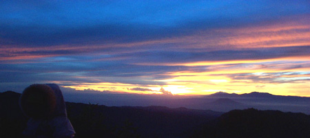
World famous is the crater Toba Lake in the Batak highlands; approximately five hours drive from Medan. Toba Lake is the largest lake in South East Asia and also one of the most spectacular, surrounded by tall mountains and with the large island of Samosir in the middle. If we descend from the mountain we see the lake glittering in all its beauty. The Dutch writer Rudy Kousbroek even called Toba Lake, 'the most beautiful place on earth'. Most visitors stay on the peninsula of Tuk Tuk on Samosir, named after the linguist Herman Neubronner van der Tuuk. In general people stay several days on Samosir to discover the island, to visit traditional Batak villages, to swim in the lake and go to the hot springs in Pangururan.
The centerpiece of North Sumatra, Lake Toba's bracing climate and magnificent panoramas clear the mind and soothe the soul. For decades a magnet from regional and foreign visitors alike, Toba has developed into a full-featured highland resort while retaining the rustic charm and relaxed ambiance that define Toba's attraction. Formed by a stupendous prehistoric volcanic explosion, the 100 km long lake is the largest in Southeast Asia and one of the deepest and the highest in the world. The drama of that cataclysmic birth persist in 500 meter cliffs dropping into the blue-green waters, surrounded by steep, pine covered sloped, the climate is fresh and pleasant, with just enough rain to support the lush vegetation.
Toba Lake is a 100kms x 30kms volcanic lake in North Sumatra, Indonesia. Toba Lake has become one of the main tourist attractions for a long time in North Sumatra apart from Bukit Lawang and Nias, visited by both domestic and foreign tourist.
The Origin of Toba Lake
It is estimated that Toba Lake was formed during a volcanic eruption about 73.000-75.000 years ago and which was the most recent super volcano eruption. Bill Rose and Craig Chesner from Michigan Technological University estimated that volcanic materials that were spewed out the mountain totaling 2800km3, with 800km3 ignimbrites rock and 2000km3 volcanic ash that is estimated was blown (wind) to the west for 2 weeks. This incident caused mass death (destruction) and to several species also causes extinction. According to some DNA proof, this eruption also shrinks the humankind population to around thousands back then.
After this eruption, a caldera was formed that was filled by water afterwards and now known as Toba Lake. The pressure from the dormant magma, which has not yet erupted, caused Samosir Island to emerge. The region that now known as Samosir Island originally was a peninsula that attached to the Sumatran mainland. In this peninsula the Netherlands built the water canal 10 m width.
For the first time visitors, going through Medan-Parapat route seeing a lake as big as that made Samosir appear like an amazing grand island. However, the island perspective will certainly faded with the increase in Toba plateau visitor, Nias and the other places in the south, through Medan-Berastagi route. Samosir occupied a central geographical position in the Toba plateau region. With the declaration of the Toba Samosir Regency (the inhabitants 302.000 lives, the area with wide of 3.440 km including the lake) it finally ascend from only a shadow into a Regency. Moreover, the width of Samosir Island exceed Singapore (647 km), in fact Toba Lake almost twice bigger than Singapore. The Samosir image in tourism books as the backpackers location must be changed because this historic place must restore the greatness of its past.
Legend of Toba Lake
Once upon a time, lived a young orphan farmer in the northern part of the Sumatran Island. This area was very dry. The young man lived from farming and fishing. One day he went fishing, he already fishing for half of the day but still not getting any fish yet. So he returned home for the day turns to night, but when he nearly left he saw a big beautiful golden fish, he then caught the fish and brought it home. He intended to cook the fish right away but watched the beauty of this fish he then cancelled his intention. He chose to keep it as pet, and then he placed it in a big pond and feed it. On the next day, like usual, he went to his farm, and on the noon he comeback home, to have lunch. But when he arrived in his house he was very startled for the meal had prepared to be eaten. He then fears that the fish might be stolen, and then hastily he ran to the back of his house.
However, the fish was still in place, for a long time he thinks, “Who cooks those meals”, but because his is very hungry, he ate those meals. But this incident continued to occur again repeatedly, every time he came home for lunch, the meals are prepared on the table. Then one day this young man made a strategy to find out who cooks those meals, the next day he then began to commence his strategy, he then hide around the trees close to his house. He was waiting for a long time, but the smoke in his kitchen still has not been seen, and when he then intended to return home, he began to see the smoke in the kitchen.
"Hey woman, who are you, and where are you came from?” the woman began to drop tears, and then the young man saw his fish was no longer in the pond. He asked the woman, “hey woman, where is the fish in that pond?” the Woman cried intensely, but this young man continued to ask and finally the woman answers, “I was the fish that was caught by you”. The young man then startled, but because he felt that he had hurt the feelings this woman, then he said, “Hey woman, did you want to become my wife??” the Woman then startled, he stay quiet, then the young man said “Why are you silent??” Then the woman said, “I wanted to become your wife. But with one condition.” ”What is the condition?” the young man quickly asked, the woman then said, “In the future if our child was born and grew, never even once you said that he/she was anakni Dekke (child of a fish) ”. The young man then agreed to that condition and swore he will never say it.
Then they were married and granted a child. When the child was 6 years old, this child turn to be very naughty. Then one day the mother told her child to deliver meals to his father field, the child then went to deliver rice to his father. But in the middle of the trip, this child was felt hungry, then the child opened food package for his father, and ate the food. After finished eating, the child then wrapped it back and continued the trip to his father's field. On arrival the child gave the food package to the father, the father was very happy, the father then sat and immediately opened the food package that was sent by his wife to be carried by his child. But he was very startled when he opened the package there is only bones remained. The father then asked his child “Hay my child, why there are only bones left in this package??” And the child answers,” In my trip I felt hungry, so I ate the food.” Listened to that the father was very angry, he then slap his child and said, "Botul maho anakni dekke (Why you child of a fish),". The child is then ran home crying and ask to his mother “Mak, Olo do na in dokkon amangi, botul do au anakni dekke? (Mother, is it true what father said, that I am a child from a fish?) ” Heard his child's words his mother was startled. While dropping tears and saying in her heart, “My husband has violated his swore, and now I must return to my place.” Then the sky was suddenly become dark followed with lightning, thunder, storm, and rain. The child and the mother disappeared, from their footprint emerged a spring that flowed water as swiftly as possible. Until this area was turned into a lake, that was named as “Tuba Lake” the lake without mercy, but because of the bataks was difficult to say “Tuba”, then this lake was mentioned as
TOBA LAKE.
According to the local Citizen, the mother return as a huge fish (the lake guardian), and until today no one is able to measure the depth of this lake. Many tourists that tried to dive into the lake but never return. The lake depth in the book is only estimation not as a fact.


 Borobudur is the biggest Buddhist temple in the ninth century measuring 123 x 123 meters. It is located at Magelang, 90-km southeast of Semarang, or 42-km northwest of Yogyakarta. Borobudur temple is the one of the best-preserved ancient monument in Indonesia that are most frequently visited by over a million domestic as well as foreign visitors. It also had been acclaimed by the world as a cultural heritage main kind. The architectural style has no equal through out the world. It was completed centuries before Angkor Wat in Kamboja. Borobudur is one of the world's most famous temples; it stands majestically on a hilltop overlooking lush green fields and distant hills. Borobudur is built of gray andesite stone. It rises to seven terraces, each smaller than the one below it. The top is the Great Stupa, standing 40 meters above the ground. The walls of the Borobudur are sculptured in bas-reliefs extending over a total length of six kilometers. It has been hailed as the largest and most complete ensemble of Buddhist relieves in the world, unsurpassed in artistic merit and each scene an individual masterpiece.
 Borobudur temple built in the eighth century by the Cailendra dynasty, is believed to have been derived from the Sanskrit words "Vihara Buddha Uhr" the Buddhist Monastery on the hill. Borobudur is a terraced temple surmounted by stupas, or stone towers; the terraces resemble Indonesian burial foundations, indicating that Borobudur was regarded as the symbol of the final resting place of its founder, a Syailendra, who was united after his death with the Buddha. The Prambanan temple complex is also associated with a dead king. The inscription of 856 mentions a royal funeral ceremony and shows that the dead king had joined Shiva, just as the founder of the Borobudur monument had joined the Buddha. Divine attributes, however, had been ascribed to kings during their lifetimes. A Mahayana inscription of this period shows that a ruler was said to have the purifying powers of a bodhisattva, the status assumed by the ruler of Shrivijaya in the 7th century; a 9th-century Shaivite inscription from the Kedu Plain describes a ruler as being "a portion of Shiva."
  The villages of Kintamani and Penelokan provide a great view of the still active Mount Batur and its fantastic lake. Seven miles in diameter and sixty feet deep, Batur caldera is simply astounding. From Penelokan, take the road Kedisan on the shores of the lake where boats can be rented to cross over to Trunyan. The spectacular mountainous region around Kintamani with its deep Crater Lake and bubbling hot springs, make this region a must to visit. Batur Lake is the largest lake in Bali and the region offers some of the most spectacular views to be found anywhere on the island. Batur Lake also provides water for an underground network of streams and springs across the southern slopes of the mountain. Kintamani is really great for day trips, trekking or simply for getting away from it all for a few days.
 Bali's smallest district Klungkung is located between Gianyar and Karangasem, and includes the island of Nusa Penida, Nusa Lembongan and Ceningan. Klungkung itself is a bustling town. Based on the decree of the Governor of Bali Province on 1993 number 528, Nusa Penida in one of with also fixed as a tourist resort in Bali. And then base of the Regency of Klungkung Government on 1996 decree number 284 there are 18 tourist object in the regency inclusive Nusa Penida. On reaching the town centre. Klungklung was the base of the ancient Javanese Hindu Kingdom in Bali, from where the Balinese royalty of today draws its bloodline. It is the oldest kingdom in Bali, with a most exalted Kings. The famous Kertha Gosa or Royal Court of Justice was built in Klungklung in the 18th century, displays one of Bali's masterpieces. It has a wonderfully made ceiling displaying one of Bali's masterpieces (murals portraying the punishment of hell and the rewards of heaven, and elaborated in thousands of panels of puppets) all on the ceiling. Klungklung's golden glory is forever captured in its floating pavilion, elaborate garden, and charming lotus ponds. Klungklung satisfies one's wish of returning to the glory of the ancient past.
 Yogyakarta Special Region (Daerah Istimewa Yogyakarta, DIY) is officially one of Indonesia's 32 provinces. Yogyakarta is one of the foremost cultural centers of Java. This region is located at the foot of the active Merapi volcano, Yogyakarta was in the 16th and 17th centuries the seat of the mighty Javanese empire of Mataram from which present day Yogyakarta has the best inherited of traditions. The city itself has a special charm, which seldom fails to captivate the visitor.
 The key attraction of Yogyakarta is 'Kraton' (the Sultan's Palace). The Sultan's palace is the centre of Yogya's traditional life and despite the advance of modernity; it still emanates the spirit of refinement, which has been the hallmark of Yogya's art for centuries. This vast complex of decaying buildings was built in the 18th century, and is actually a walled city within the city with luxurious pavilions and in which the current Sultan still resides. Yogyakarta is also the only major city, which still has traditional 'Becak' (rickshaw-style) transport.
  Geographically, Yogyakarta Special Province is situated in the Southern part of Central Java and lies between 7 degree 33' and 8 degree 12', South altitude between 110 degree and 50' East longitude. Some regencies of central Java Province surround the administrative boundaries of this region:
 Because of its location, Yogyakarta is strategically positioned for the economic activity network in Java as well as for the tourist destination area. The special region of Yogyakarta lies midway on the axis of several main tourist destination areas, Jakarta and West Java westward, Central Java northward, East Java and Bali eastward. It is linked by regular rail, road and air services to other parts of Indonesian archipelago.
 The average daily temperature range between 26 degree and 28 degree Celsius with its minimum 18 degree C and maximum 35 degree C respectively. Average humidity is 74% with its minimum of 65% and maximum 84% respectively. The Yogyakarta Special Region lays approximately 7 South of the equator line and is bathed in tropical; sunshine along the year. This region has a tropic climate the daily atmosphere feels a little bit hot and humid. These are only two seasons along the year, the wet or rainy seasons and dry monsoon. Usually the wet seasons begin at September and lasts about August. Generally there is no rainfalls from may to August and there fore the atmosphere feels hot and humid on the day and cool in the night and early morning. The monthly rain falling Yogyakarta varies between 3mm and 496mm in which those above 300mm take place during the month of January up to April. The heaviest rainfall usually occurs in February while the lowest commonly happens between May and October Average annually rainfall is about 1,900mm.
 Based on 2000, the total population of Yogyakarta special Region amounted to 3.311.812. Yogyakarta Municipality that has 461,800 inhabitants spread over 32,50 kilometers or the average population density is thus over 14,200 persons per square kilometer. The least densely populated districts is in Gunung Kidul regency which has 720.643 inhabitants and cover 1,485 square kilometers or the density rate is 485 persons per square kilometer. Since a very long time ago the Provincial territory of Yogyakarta Special Region and its surrounding has been decently populated.
 The culture Yogyakarta province with its status as a special region lies in the Southern part of Central Java, in the heartland of Javanese culture. As the former capital and the center of several kingdoms in the past, this region and its people are very rich in a variety of cultures. It is widely known from to historical records that the civilization, art and culture had developed well in the center of those kingdoms respectively in the Ancient Mataram Kingdom (8th - 10th Century) era, the second Mataram Kingdom (17th - 18th Century) and Sultanate Ngayogyokarto from the mid of 18th Century up today.
 It should be noted that the cultural heritage from the past includes the magnificent temples, the ruins of palaces and monasteries, the various kind of traditions, cultural events, traditional folk and performing arts, architecture and other traditional activities. It is important to note that this is all part of the living culture of Yogyakarta, color of daily activities of live and the local inhabitants behavior, particularly the Javanese community with its traditional way of life and customs. Therefore, because of its culture richness and heritage, Yogyakarta has long been known as the cradle of Javanese culture.
 The other legendary name for Yogyakarta City, among the elders as well as the youth generation that is the City of Art and Culture. Traditional and modern exhibition are held almost every day and night about the art of theater, pantomime, music, classic and contemporary dances, poems, etc. Those are flow in the heart of the city. Even more, there are abundant of cultural ceremony, such as Sekaten, Gunungan, Labuhan, Malioboro Fair, etc, which make the city has high value of tradition, art, and culture.